Raising Water Consciousness through
World’s Biggest Photo Exhibition and
Largest collection of Photo Stories on Water
Photo Stories | Water and Environment
Living Below the Sea Level: Its Impact on the Wetlands of Kuttanad, Kerala
Nandita Singh and Om Prakash Singh
28 February, 2019
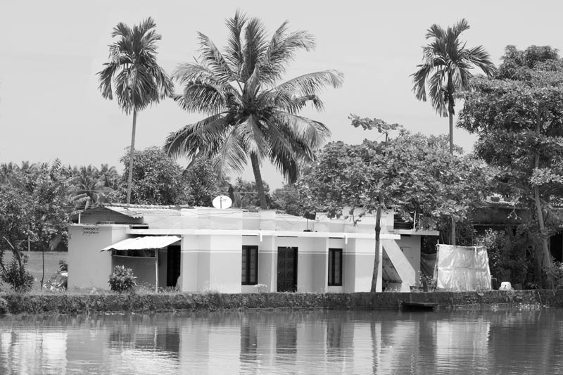
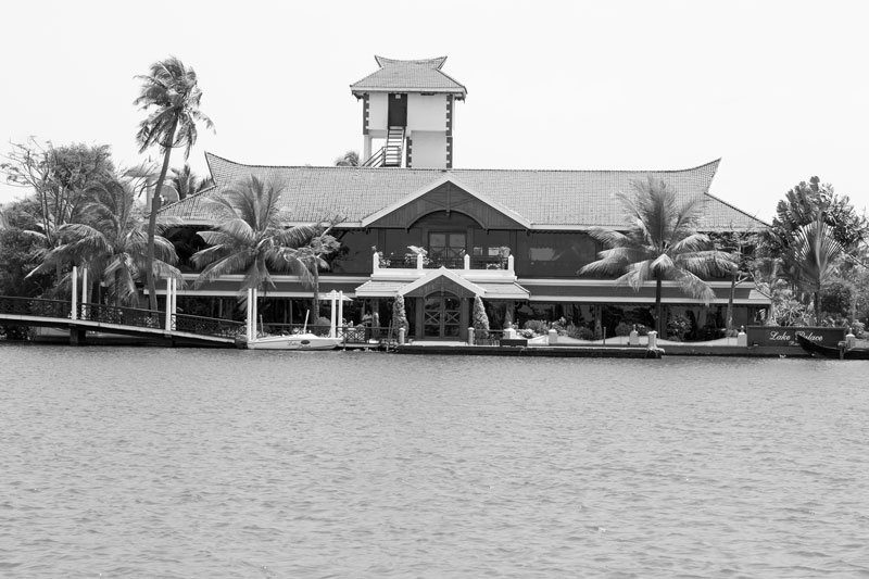
The State of Kerala has the largest area under wetlands in India, with a total 1,606 sq. km. spread across 217 wetland units. Of these, the wetlands of Kuttanad, spread over an area of approximately 900 sq.km., are located in the southern part of India's largest Ramsar site - the Vembanad-Kol wetland. Kuttanad is a deltaic formation of four rivers, namely Meenachil, Pamba, Manimala and Achenkovil, and comprises primarily of marshes, vast network of water channels, and Vembanad Lake. With about two-thirds of the area lying 0.6-2.2 m below the mean sea level (MSL), the region was originally characterized by natural water-logging throughout the year. Available historical evidences indicate until that about two centuries ago, there was little human colonization in Kuttanad. Transformation of the region began in the early 19th century when large-scale reclamation of the naturally fertile floodplain marshes for agriculture and habitation started. Even the shallow parts of the Vembanad Lake bed came to be converted into polders for paddy cultivation. Eventually, large human populations settled down, practicing diverse livelihoods including paddy cultivation, coconut farming, fisheries, and lately, backwater tourism. The resultant unique lifestyle below the sea level in Kuttanad has been illustrated in the photo story dated 15 November 2018, while glimpses of the diverse livelihoods practiced here have been presented in the story dated 15 December 2018. The wetlands of Kuttanad have supported human populations to survive and thrive below the sea level through decades by offering multifarious ecosystem services. However, the human colonization has resulted in serious impacts on the water resources of this wetland, which are so immense that today it has come to be regarded as one of the most seriously threatened wetland systems of India. It is estimated that more than one-third of the waterspread area is lost due to land reclamation, and the expanse of Vembanad Lake itself is reduced by about two-thirds. Further, depth of the lake is substantially reduced and water quality in the lake, water channels and marshes is highly degraded. As a result, the various ecosystem services provided by this wetland are threatened; the rich biodiversity supported by it are increasingly eroded; the livelihoods base of the dependent communities are challenged; the human right to water of the women, men and children inhabiting the wetland is thwarted; and ultimately, sustainable development in the region is at stake. This photo story aims to illustrate the impacts that living below the sea level has made on the quality and quantity of water resources in the wetlands of Kuttanad and its implications for sustainable development. The title photo presents glimpses of a human settlement along with houseboats for tourism in the backwaters of Kuttanad in Alappuzha district, Kerala.
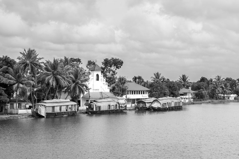
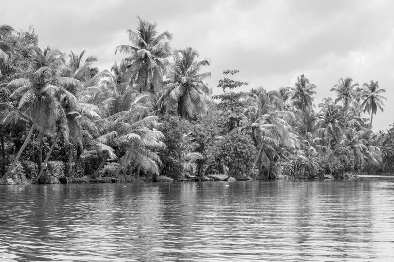
Vembanad Lake - an important lifeline for the inhabitants of Kuttanad wetlands in Alappuzha district, Kerala
The wetlands of Kuttand form an important segment of the Vembanad-Kol wetland complex which has been designated as 'Wetland of International Importance' under the Ramsar Convention. It is a unique wetland with an ecosystem that provides a variety of services which has enabled human populations to survive and flourish through almost two centuries. Its 'provisioning' services primarily include freshwater availability for below-sea-level agriculture and drinking water supply, fish production and inland navigation. Its 'regulating' services include maintenance of hydrological regimes, particularly providing flood protection by acting as a sink for the heavy monsoon flood flows. Its 'cultural' services concern aesthetic value, recreation and tourism. Kuttanad is a biodiversity paradise, being home to several rare mangrove species as well as migratory fish species and birds, which in turn support its different ecosystem services. Vembanad Lake, shown in the above photo, is the largest water body in the Kuttanad wetlands, from the shallow parts of which land for agriculture and settlements has been reclaimed, and which serves as the most important source for catch fish, besides inland navigation and other functions.
Ongoing land reclamation for settlement in the wetlands in Alappuzha district, Kerala
Human colonization in the wetlands of Kuttanad has been made possible through the process of land reclamation in the permanently or seasonally submerged areas. Large patches in the marshes and even in the Vembanad lake bed have been retrieved for settlement and agriculture by raising embankments, followed by filling up with sand and clay from the river or lake bottom, as shown in the photo above. According to a 2013 report prepared by Wetlands International – South Asia, as much as 550 sq.km. out of a total area of 900 sq.km. in Kuttanad consists of reclaimed land. About half of this is land reclaimed from the lake while the rest is from the floodplain marshes of the four rivers. While these reclaimed lands are of great socio-economic value, the resultant loss of wetlands has drastically reduced the water holding capacity of the region during the last 50 years. This, in turn, regularly leads to inundation of the peripheral areas and occasional floods during the monsoon season. To be noted is the flood of 2018 when entire Kuttanad was inundated, something the region's history had never seen before.
A human settlement on reclaimed land in the Kuttanad wetlands in Alappuzha district, Kerala
The wetlands of Kuttanad is estimated to be home to about 2 million inhabitants. The region is densely populated, with people residing in as many as 78 revenue villages, 25 census towns, and seven Municipalities, spread across three districts - Alappuzha, Kottayam and Pathanamthitta. Many of these settlements are a result of land reclamation, with houses and buildings constructed on embankments raised in the marshy lands or the lake bed, an example of which is shown in the photo above. Conversion of marshes and lake area into residential plots amounts to encroachment of these wetland bodies, with serious implications for the wetland ecosystem, including the quantity and quality of the water resources.
'Garden land' amid wetlands – coconut plantation interspersed with banana and other crops along an embankment in Alappuzha district, Kerala
More than one-third of the area of Kuttanad consists of 'garden lands' or 'purayidams' which are reclaimed lands raised to a height of about 0.5 to 2.5 m above MSL. These lands are used for habitation as well as coconut-based agroforestry where the palm is grown integrated with fruit trees like banana, mango, jackfruit and tubers like yams and taros. The area under garden lands is expanding in recent decades, due to the trend of converting paddy fields into garden lands which offer greater economic security. However, paddy fields are considered as man-made wetlands that serve several important hydrological functions, and hence, their gradual disappearance is detrimental to the future of Kuttanad wetlands.
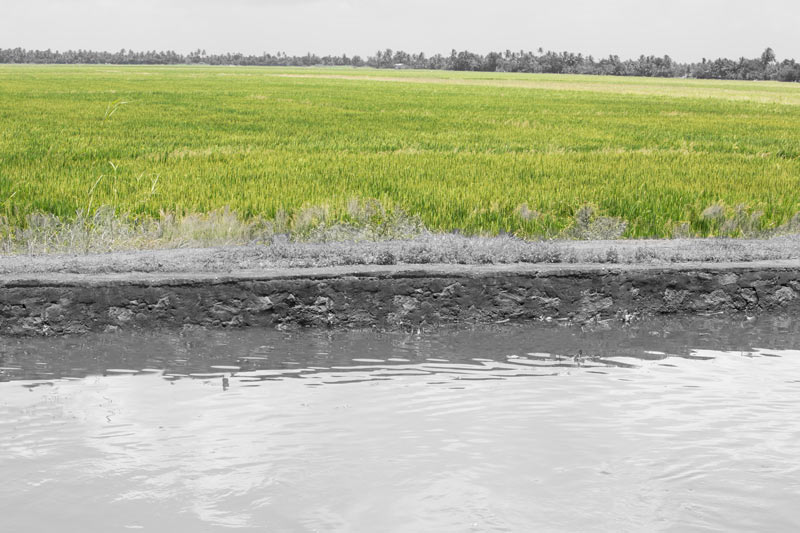
A block of paddy fields next to an embankment in Alappuzha district, Kerala
About one-third of the area of Kuttanad wetlands consists of paddy fields which have been reclaimed from the marshes and the lake bed. Blocks of paddy fields - called 'padshekharam' (or polders) - as shown in the photo above – have been created by raising double embankments with sluices all around for keeping the excess water of the wetland out or letting it in only when required. There are about 1,350 padshekharams in Kuttanad, where paddy cultivation is practiced as the economic mainstay by over 90,000 farmers. Starting in the 19th century with only one paddy crop in 2-3 years, over the last few decades, paddy has come to be cultivated intensively round the year in three cycles, namely Punja (November to March), Virruppu (mid-May to September) and Mundakan (September to December). This has had a deep impact upon the water resources of the wetland.
Paddy fields lying adjacent to a water canal in Alappuzha district, Kerala
The padshekharams lie adjacent to canals in the Kuttanad wetlands as shown in the photo above, which further drain into rivers or the lake. These canals serve an important function in the cropping cycle. During the phase of dewatering, these canals receive the excess water pumped out from the fields, while during the phase of irrigation, they hold water received from the river channel or lake, which is then applied to the crop in the fields. As a result of the inherent regular transfer of water between the fields and the canals and their proximity to the fields, there exists high possibility of the canals receiving any pollutants from the adjacent fields which may be rich in fertilizers and pesticides.
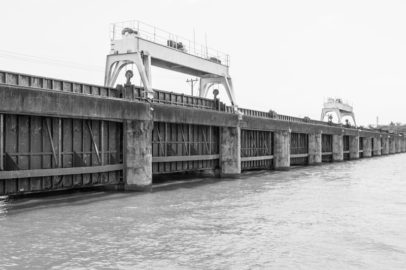
The Thanneermukkom Saltwater Barrier in Alappuzha district, Kerala
For improving agricultural production below the sea level, an important engineering work constructed in Kuttanad is the Thanneermukkom Saltwater Barrier shown in the photo above. It is a 1,252 m long structure constructed at a narrow segment of Vembanad Lake, between Thanneermukkom and Vechoor, functional since 1974. It was designed to prevent salinity ingress in the dry season and retain freshwater from the inflowing rivers into Kuttanad region to enable safe punja crop and intensify viruppu crop of rice. With the gates remaining closed during December to March, the barrier has been relatively successful in reaching its goal, but not without severe ecological consequences triggered by changes in the natural hydrological processes and salinity regimes. An important outcome is the elimination of tidal flushing which has exponentially enhanced pollution levels in the soil and water bodies of Kuttanad.
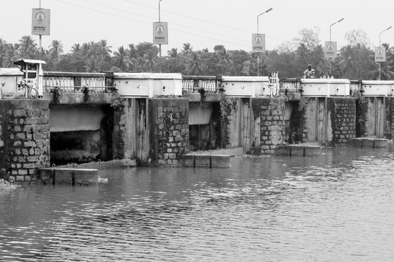
Thottapally spillway in Alappuzha district, Kerala
Another engineering intervention for improving agricultural production in Kuttanad was the Thottapally spillway which was constructed in 1955. Its purpose was to enable speedy diversion of monsoon flows of Achencoil, Pamba, Manimala and Meenachil rivers in order to reduce flooding in the agricultural lands. The spillway is in the form of a bridge-cum-regulator which connects to the Arabian Sea at Thottapally through a 9 km long lead channel from the rivers. It is opened during June to December and closed during rest of the year to prevent saline water intrusion. However, its capacity to divert floodwaters has been insufficient, and floods persist as threat to agricultural productivity in Kuttanad.
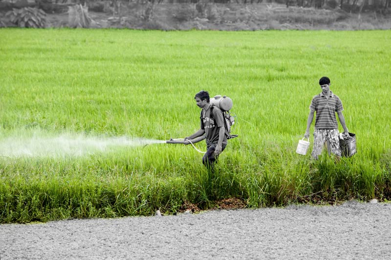
Pesticide being applied in paddy fields for enhancing productivity in Alappuzha district, Kerala
In the beginning, paddy cultivation in the wetlands of Kuttanad involved raising of traditional crop varieties using organic manure. However, after independence, for promoting economic development in Kuttanad, high-yielding varieties of rice were introduced under the 'Green Revolution'. These crops demanded intensive use of fertilizers and pesticides for higher productivity. Consequently, pesticides have come to be regularly applied on standing crops of paddy and others in Kuttanad, as shown in the above photo. Way back in 1990, an Indo-Dutch Kuttanad Water Balance Study reported that about 25,000 tonnes (t) of fertilizers and 500 t of pesticides were already used annually in the region's paddy fields. These figures have obviously multiplied over the decades and a considerable portion of these enters the canals, rivers and the lake when the runoff is drained out from the fields. In recent years, rising number of cancer cases is reported in the region, which is attributed to the indiscriminate use of pesticides and chemical fertilizers.
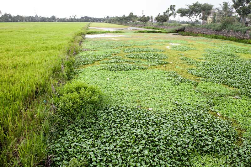
Eutrophication in a water canal adjoining paddy fields in Alappuzha district, Kerala
As a result of the heavy use of fertilizers, the water drained out from the paddy fields into the canals of the padshekharams becomes rich in nutrients, particularly in nitrogen and phosphorus. This in turn drains into river channels and the Vembanad Lake. A cumulative consequence is increasing eutrophication in the backwaters of Kuttanad.
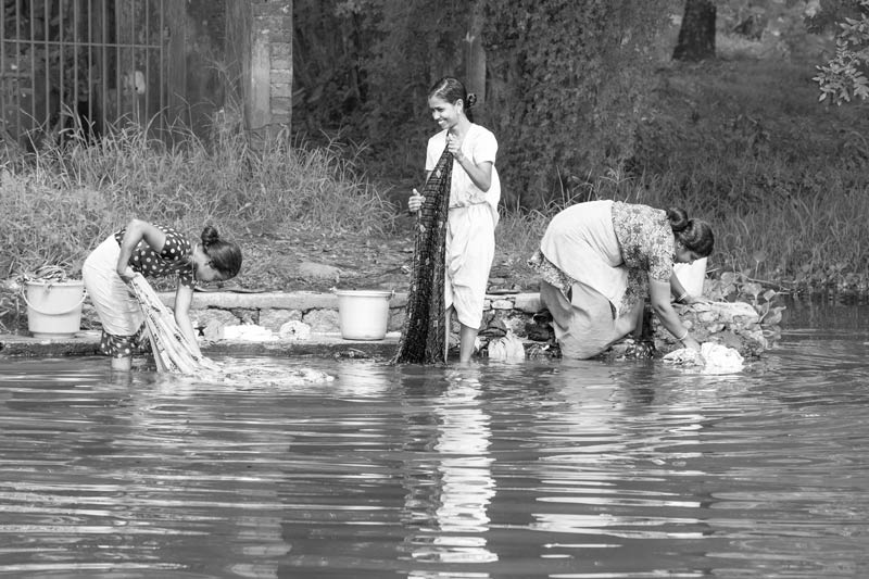
Clothes being washed in the backwaters in Alappuzha district, Kerala
There is a high dependence on the backwater canals for daily chores in Kuttanad, especially in areas reclaimed from the lake bed. It is a common sight to see people bathing, doing laundry, and cleaning utensils along the embankments, a glimpse of which is presented in the above photo. These activities contribute significantly to microbial and chemical contamination of water. There is also high coliform count due to poor sewage disposal arrangement in these settlements, with toilets in many households having direct outlets into the backwater system. Further, large amounts of raw sewage from towns like Alappuzha is discharged directly into the backwaters. Since surface- and groundwater are interconnected resources, this has led to overall degradation of drinking water quality in Kuttanad, the consequence of which becomes visible in the form of frequent outbreaks of epidemics like diarrhoea and increasing cases of filariasis, schistosomiasis, typhoid, jaundice, gastroenteritis and cholera.

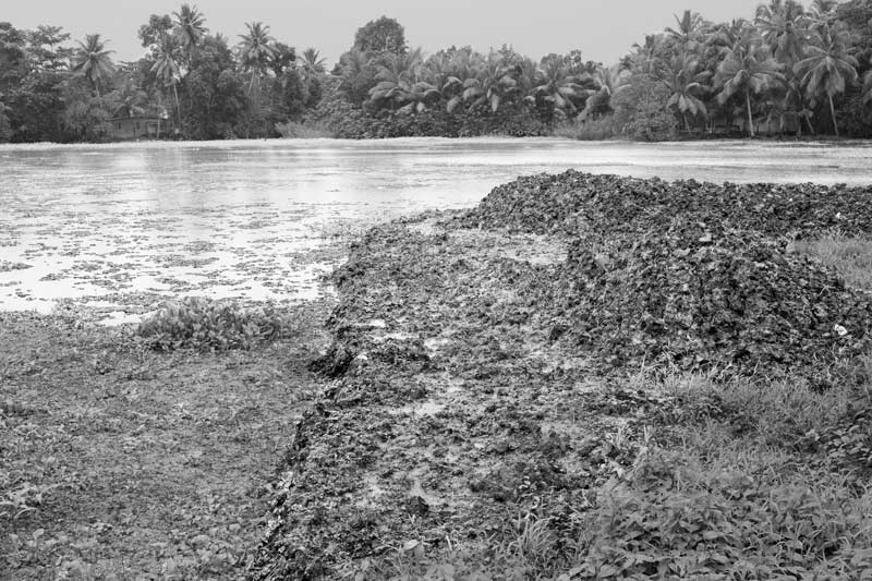
Solid waste piled up in fallow marshes in Alappuzha district, Kerala
Lack of basic amenities is a hallmark of many settlements in the wetlands of Kuttanad. Apart from lack of access to safe water and sanitation, there is also absence of proper solid waste management facilities. Solid waste generated from the households and also tourist locations, which are on the rise, simply pile up along the embankments, banks of the lake and rivers, and fallow marshes as shown the photo above, causing further water quality degradation in the canals and the lake. This also interferes with water flow in the canals, affecting water drainage in the floodplain and obstructing inland navigation in extreme situations.
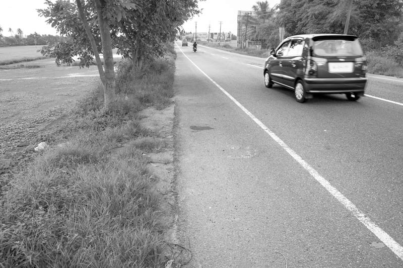
The Alappuzha-Changanassery (A.C.) Road in Alappuzha district, Kerala
The A.C. Road, running from east to west across the middle of Kuttanad, was constructed in 1957 to facilitate transport and communication in a region where earlier inland navigation was the only possibility. Later, several other roads and bunds have been constructed across the low-lying floodplains. Despite the socio-economic benefits derived from the roads network, its implications for the fragile water ecosystem of Kuttanad have been immense. These have been criticized for their unscientific construction resulting in blockage of water flow in the canals, in turn causing flooding in the region as well as stagnation of waste in the polluted water, with negative health and environmental consequences.
A fish farm in Alappuzha district, Kerala
Inland fisheries is being undertaken in a large way in the Kuttanad wetlands. The farmed varieties include fin fish as well as shell fish, and besides specially created fish farms as shown the photo above, even paddy fields are leased out by farmers to fishermen for the purpose. Though a lucrative business, fish farming below the sea level comes with a heavy ecological price. Fertilizers and pesticides, along with other chemicals are added to enable thriving of the fish crop, and these in turn further deepen the problem of water quality degradation in the region.
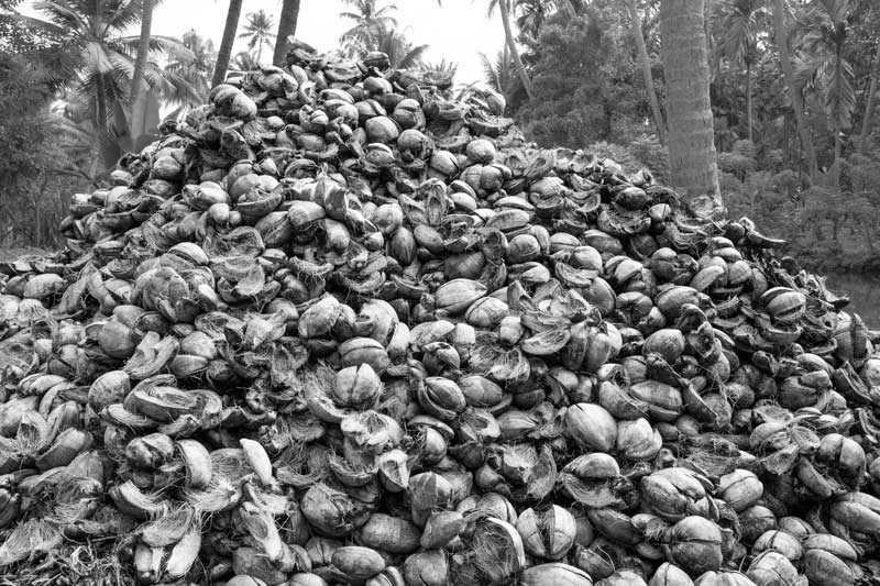
Coconut husk piled up for industrial processing in Kottayam district, Kerala
Coconut is the second most important agricultural produce in the wetlands of Kuttanad. Apart from the value of the fruit itself, coconut husk retting is an important income generating activity. Mainly carried by womenfolk, it is estimated to provide income to 18,000 households and as per 2012 estimates of the Directorate of Coir Development, 3.58 t of coconut fibre are annually retted in the region. Coir retting involves defabrication of coconut husk by dipping in lake water for six months. This contributes to water pollution due to release of enormous quantities of organic pollutants, leading to depletion of dissolved oxygen in water, hence endangering the wetland's flora and fauna. Other industries in the region are also important source of pollution, discharging hazardous substances like fluorides, mercury, chromium, sulphides and insecticides into the lake and water channels.
A tourist resort in the midst of Vembanad Lake in Alappuzha district, Kerala
Given the serene beauty of Kuttanad wetlands, there has been a boom in backwater tourism since 1990s. Around 1.1 million tourists are estimated to visit Kuttanad and adjoining areas annually and this sector is estimated to form the economic base for nearly 85,000 households in the region. In order to accommodate the rising number of tourists, new hotels and resorts are being constructed, leading to further encroachment of the lake bed and waterspread areas. Further, mangroves and trees which played an important role in water retention in the wetlands have been cleared off for the development of tourist complexes and resorts. More importantly, these resorts lack proper wastewater management systems, leading to disposal of raw sewage as well as solid waste directly into the backwaters.
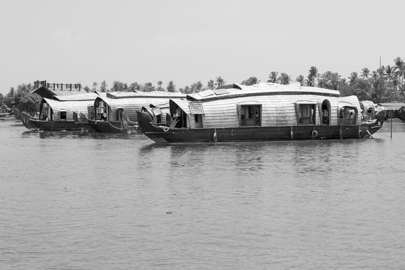
Houseboats – the backbone of backwater tourism in Kuttanad in Alappuzha district, Kerala
Houseboat tourism is the most popular activity of backwater tourism in Kuttanad. Houseboats, shown in the above photo, are traditionally called 'Kettuvalams' and serve as floating cottages for tourists. It is estimated that more than 1,300 houseboats are operational in the region. Despite the economic potential offered by houseboat tourism, the threat posed by this industry to water sustainability in the wetlands is immense. These are an important source of water pollution through direct disposal of raw sewage and solid waste, besides fuel spillage.
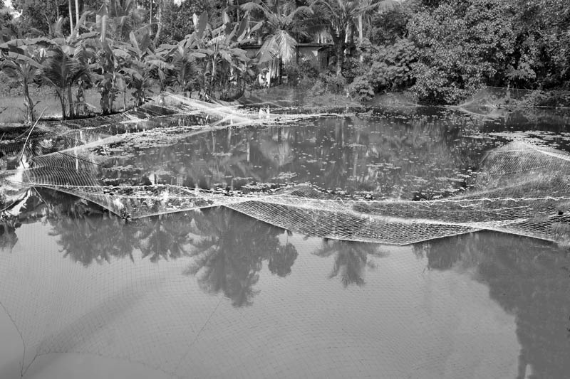
Water hyacinth proliferating in Vembanad Lake in Alappuzha district, Kerala
As noted before, the water of Vembanad Lake as well as the canals and streams in Kuttanad wetlands is very rich in nutrients, resulting from nutrient transport through agricultural runoff and untreated human waste sourced from the urban and rural settlements and the houseboats. Closure of Thanneermukkom Saltwater Barrier for extended periods is an important contributing factor too because this has led to significant reduction in tidal flushing in Kuttanad, which could have otherwise helped flush out the nutrients. As a result of eutrophication, alien invasive species like Kariba weed (Salvinia molesta) and water hyacinth (Eichhornia crassipes) have spread densely in the lake, canals and drains. These in turn impede water flows, prevent inland navigation, deplete dissolved oxygen and interfere with the entry of sunlight into water, thereby further adversely affecting fish reproduction and growth.
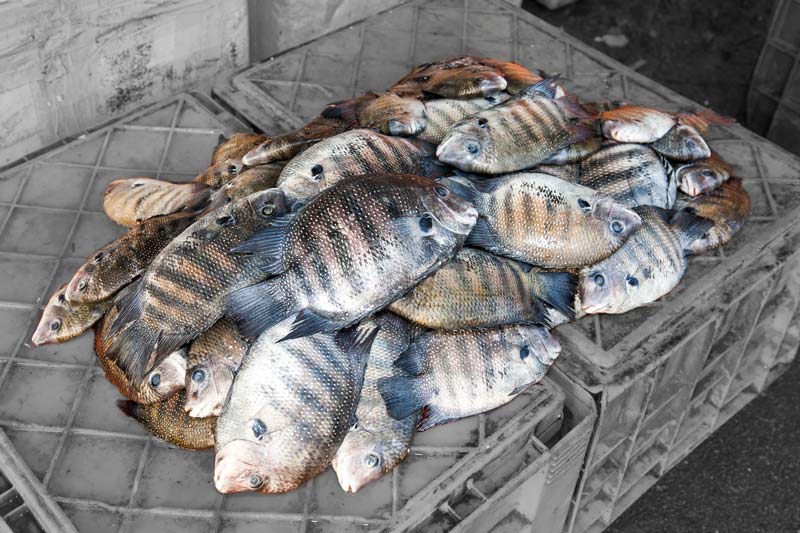
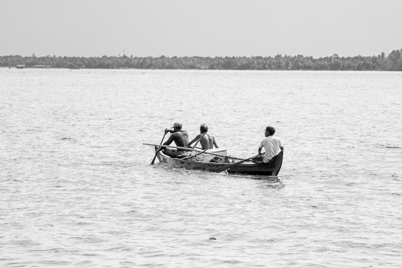
A fresh catch of Karimeen fish in Alappuzha district, Kerala
Kuttanad was known for its fish diversity which included 149 species and until early 1990s, fishing was an important source of livelihood for over 17,000 households in and around Vembanad Lake. However, significant decline in fish diversity and density over the last three decades has significantly reduced its potential, reducing the number of fishing households by about three-fourths. Some of the commercially important species like milk fish (Chanos chanos), marine cat fish (Tachysurus), pearl spot (Etroplus suratensis), giant freshwater prawn (Macrobachium), have either vanished or become a rarity. This status can be attributed to changes in the prevailing water regimes in the wetlands. These include disruption of the physical and biological continuity of the lake with the coastal waters caused by construction of Thanneermukkom Saltwater Barrier, which also caused changes in salinity regimes; disruption of the hydrology caused by blocked waterways; loss of breeding habitats due to mangrove destruction and sand mining; and increasing water pollution. For example, the catch of Karimeen or pearl-spot shown in the photo above, which is the most favored and prized species of Kuttanad and the State Fish of Kerala, has drastically dropped to just about one-tenth of the original.
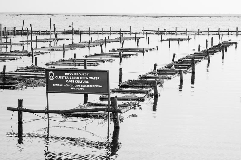
Experimental cage culture of Karimeen at Regional Agricultural Research Station, Kumarakom in Kottayam district, Kerala
The wetlands of Kuttanad was a biodiversity treasure, but today this waterscape is highly modified and fragmented, leading to endangering and even vanishing of some faunal varieties. The status of fish populations and the causes underlying their dismal situation has been described above. The wetlands were also an important habitat for a rich diversity of birds including several migratory species but even the bird population has declined sharply by more than 40% since early 1990s, for similar reasons as cited above. Efforts are now being made for conservation of some of the sensitive species in the wetlands of Kuttanad. Examples include the fish sanctuary and experimental high-density cage culture for Karimeen, both established at the Regional Agricultural Research Station (RARS), Kumarakom. Of these, the latter depicted in the photo above, has succeeded in improving fish yield 12-50 times compared to that from conventional pond culture or even natural sources.
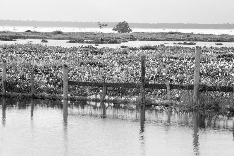
Mangrove restoration attempted at Regional Agricultural Research Station, Kumarakom in Kottayam district, Kerala
The shores of Vembanad Lake were home to luxuriant mangroves but these have been indiscriminately removed primarily for constructing infrastructure for tourism promotion. At present some mangrove forests appear in small patches. Reduction in the forest coverage in the catchment area has reduced the water holding capacity of the wetlands and also resulted in excessive soil erosion and sedimentation of the lake bed. Mangrove forests also served as important roosting and breeding sites for several bird varieties. Keeping these benefits of mangroves for maintaining the ecology of the wetlands, an attempt to restore mangrove forests on the shores of Vembanad Lake is being made at RARS, Kumarakom, as shown in the photo above.
This photo story has elucidated how living below the sea level in the wetlands of Kuttanad has played havoc with its water resources in terms of both quality and quantity. Undoubtedly, colonization of the wetlands and creation of polders for agriculture itself signified an onslaught on the water wealth of the wetland. However, this bountiful wetland was able to sufficiently provide for people's 'needs' through all the three basic ecosystem services, namely, provisioning, regulating and cultural, with water as the central resource. The ecosystem services could continue efficiently until these remained in balance with nature, seen for example, in terms of synchronization of cropping cycle and varieties with prevailing hydrological regimes, use of organic farm inputs, low population pressure, and a 'need-based' economy in general. However, transition from 'needs' to 'greed' in the name of economic development especially in the post-independence period, led to major transformations in the waterscape, which have made long-lasting adverse impacts in terms of both quality and quantity of water. These include construction of the Thanneermukkom Saltwater Barrier and the Thottapally Spillway and introduction of high-yielding varieties of paddy under the 'Green Revolution'. Industrialization in the region, expansion of rural and urban settlements, and rise of backwater tourism dealt further blows, further encroaching the water bodies and adding to the pollution load. The situation has worsened to the extent that though people live in beautiful houses, in many pockets, they cannot even enjoy the basic human rights to water and health because the drinking water locally available is polluted. Similarly, floods regularly wreak havoc because construction of roads, culverts and excessive growth of weeds in the watercourses have blocked the natural water drainage systems. Quality and quantity problems of water have in turn led to decline of the aquatic fauna. Seen cumulatively, the status of water resources in the Kuttanad wetlands has reached a stage where the traditional livelihood comprising agriculture, fisheries in natural waters and other associated activities are no longer economically viable. There is general agricultural distress and inequity and poverty is making inroads. Development of backwater tourism is further deepening the crisis through multiple pathways connected to water.
It thus emerges that living below the sea level in the Kuttanad wetlands is severely challenged today primarily due to neglect of the ecological dimension of sustainability that has in turn thwarted social and economic sustainability. Given this background, for ensuring sustainable development in Kuttanad, there is an urgent need to halt any further damage to the water resources in this unique ecosystem below the sea level and also implement strict measures for rectifying the damage already done. Some of the important measures include halting further encroachment in the lake and other water bodies, regulating conversion of paddy fields into garden lands, promotion of organic farming, development or reintroduction of seed varieties that synchronize with the seasonal hydrological regimes, operation of the saltwater barrier in a manner that allows for tidal flushing, stopping deforestation and promoting afforestation of mangroves, strict regulation of the number of houseboats plying in the region, installation of well-functioning municipal sewage treatment plants, safe management of solid and liquid waste generated in the local settlements and by houseboats and tourist resorts, and strict regulation of effluent disposal and management by industries. Simultaneously, for facilitating enjoyment of the human right to water, the network of piped water supply should be expanded, and regularity of supply ensured, besides promotion of rooftop rainwater harvesting for drinking water in localities where expansion of piped water supply is not possible.
The agro-based economy practiced below the sea level in the Kuttanad wetlands is popularly known as 'Kuttanad Wetland Agriculture System' and this has been declared by the FAO as a 'Globally Important Agricultural Heritage System' (GIAHS). Given parallels between the Kuttanad below the sea level ecosystem and submergence caused by climate change induced sea-level rise, the Kuttanad model is being promoted for designing adaptation in at-risk island States like Maldives and coastal countries like Bangladesh. But before applying it as an adaptation model, there is need to make an assessment of its potentials and limitations from the perspective of water and sustainable development, and plan adaptation accordingly. Otherwise, there would be risk of 'maladaptation' instead. There is also need to exercise caution and apply the Kuttanad model for adaptation to only submergence from sea level rise, but never for promoting human colonization within living natural wetlands.